 The Channel Islands were the only part of the British Commonwealth to be occupied by the German Army during World War Two. Even after D-day brought the war back into France in 1944, the Germans remained on the islands. Was it worth the effort for 194 km² of rock in the English Channel? Why were the islands targeted?
 In order to answer this question, one must be familiar with the geographic location of the Islands. This map to the right provides a clear view.
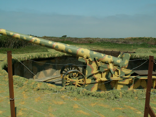
As we can see, the islands could be used as a strategic outpost for shelling the British Coast, as a port for wartime naval craft, and even had the potential to be a stepping stone for invasion. During the occupation, the islands were utilized for shelling, with thousands of entrenchment systems, Martello 'look-out' towers and fortifications and artillery trenches, all built by P.O.W. slave labour.
However, if we consult the map once more, it is apparent that the Islands are actually much closer to France than Britain, and there are points on the French coast where there is a much smaller distance between the French beaches and the British cliffs. So why were the Channel Islands targeted and so heavily fortified?
 I believe that the main motive for the initial invasion and the resilience in which the German occupation force held out can probably be attributed to the fact that the islands were British. This small collection of islands were the only region of British Commonwealth that was successfully invaded. While the mainland resisted invasion in the Battle of Britain, the Islands remained captive for the entirety of the war. I believe the underlying reason for this is simply vindictiveness from the German High Command. To the German Army, and the Nazi regime, it could be seen as a victory; something that became even more important after the War turned and the soviet Red Army began butchering their way to Berlin. Stubbornness and resilience can be seen throughout the occupation, for example when the Royal Navy attempted to starve the invaders out with a blockade in 1944 (one of the only actions taken in an attempt to free the Islands) to no avail. Eventually the blockade was abandoned. The naval blockade made the conditions for the Islanders even worse, and resentment for the British for not coming to their aid would no doubt have increased as many began to starve. It is detachments like these that i wish to research in an attempt to see if there are still 'hurt feelings' as such.
 On a side note, as Holocaust Memorial Day has recently passed, I wish to pay respects to the 700 that died in concentration camps on the Islands, the only on British soil. 6,000 people were impounded in the camps during the occupation, and the inhabitants were given minimal rations and forced to work until exhaustion, or even death. Please remember them.
No comments:
Post a Comment